Import a GPX file

Ward Farm Recreation and Nature Park loop

  • Distance: 2.4 mi
  • Elevation gain: 51 m
  • Maximum elevation: 37 m
  • Elevation loss: 52 m
  • Minimum elevation: 4 m
  • Moving time: 52 m 30 s
  • Moving speed: 2.7 mph
  • Maximum speed: 4.4 mph
  • Total time: 58 m 12 s
  • Global speed: 2.4 mph

Interactive trail map

Trail profile

  • Distance: 2.4 mi
  • Elevation gain: 51 m
  • Maximum elevation: 37 m
  • Elevation loss: 52 m
  • Minimum elevation: 4 m
  • Moving time: 52 m 30 s
  • Moving speed: 2.7 mph
  • Maximum speed: 4.4 mph
  • Total time: 58 m 12 s
  • Global speed: 2.4 mph

About this trail

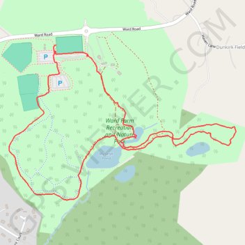
Name: Ward Farm Recreation and Nature Park loop trail, distance, elevation, map, profile, GPS track

Start: Ward Road, Woodlawn Farms, Dunkirk, Calvert County, Maryland, 20754, United States (38.72134 -76.64697)

End: 1, Ward Road, Woodlawn Farms, Dunkirk, Calvert County, Maryland, 20754, United States (38.72159 -76.64694)

Coordinates: 38.71487 -76.64953 38.72159 -76.63694

Gear up for your next adventure:

👟Women's Trail Running Shoes - Agile footwear for fell running and technical trails
🗺️Topographic Maps - Detailed maps showing elevation and terrain features
🧭Orienteering Compasses - Accurate compasses for map-based navigation
🖼️Topographic Map Art - Decorative 3D-effect posters of famous UK peaks and regions
🧼Biodegradable Soap - Leave-no-trace hygiene for multi-day mountain treks

As an Amazon Associate, this site earns from qualifying purchases at no extra cost to you.