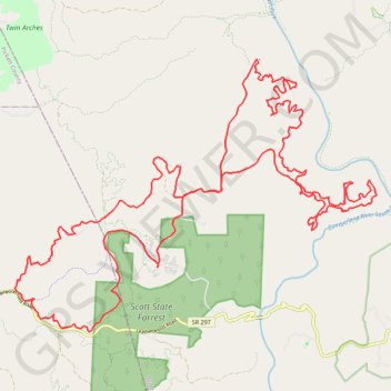
Big South Fork MTB Loop
Mountain Bike loop in the Big South Fork National River and Recreation Area. Cumberland River South Fork. Scott State Forest. #MTB #Loop #River #Forest #Nature
- Distance: 32.4 mi
- Elevation gain: 1,226 m
- Maximum elevation: 492 m
- Elevation loss: 1,226 m
- Minimum elevation: 356 m
- Moving time: 5 h 50 m
- Moving speed: 5.5 mph
- Maximum speed: 33.0 mph
- Total time: 7 h 16 m
- Global speed: 4.5 mph
Interactive trail map
Trail profile
- Distance: 32.4 mi
- Elevation gain: 1,226 m
- Maximum elevation: 492 m
- Elevation loss: 1,226 m
- Minimum elevation: 356 m
- Moving time: 5 h 50 m
- Moving speed: 5.5 mph
- Maximum speed: 33.0 mph
- Total time: 7 h 16 m
- Global speed: 4.5 mph
About this trail
Name: Big South Fork MTB Loop trail, distance, elevation, map, profile, GPS track
Start: Bandy Creek Loop, Scott County, East Tennessee, Tennessee, United States (36.48808 -84.69839)
End: Bandy Creek Loop, Scott County, East Tennessee, Tennessee, United States (36.48807 -84.69844)
Coordinates: 36.47303 -84.73916 36.53598 -84.63554
Other hiking, mountain biking, running and outdoor activity trails
Click on a trail to view its statistics, map and profile.
Katie, Jack's Ridge, Black House Branch, Station Camp Creek and Duncan Hollow Trails
United States > Tennessee > Scott County
Big South Fork National River and Recreation Area
Distance: 16.2 mi • Elevation gain: 556 m • Maximum elevation: 487 m
Big South Fork National River and Recreation Area
United States > Tennessee > Scott County
Scott County Dia
Distance: 18.1 mi • Elevation gain: 668 m • Maximum elevation: 487 m
John Litton Farm Hike Loop
United States > Tennessee > Scott County
Scott State Forest, Fall Branch, Scott County Trail Running
Distance: 4.7 mi • Elevation gain: 159 m • Maximum elevation: 481 m
Cumberland Valley Loop Trail
United States > Tennessee > Fentress County
Fentress County Dia
Distance: 18.2 mi • Elevation gain: 513 m • Maximum elevation: 485 m
Leatherwook Loop Trail
United States > Tennessee > Scott County
Scott County Hiking
Distance: 4.0 mi • Elevation gain: 230 m • Maximum elevation: 447 m
Scott State Forest
United States > Tennessee > Scott County
Scott County
Distance: 17.4 mi • Elevation gain: 388 m • Maximum elevation: 485 m