Pintail Marsh
- Distance: 3.5 mi
- Elevation gain: 16 m
- Maximum elevation: 177 m
- Elevation loss: 15 m
- Minimum elevation: 172 m
- Moving time: 40 m 49 s
- Moving speed: 5.2 mph
- Maximum speed: 15.0 mph
- Total time: 1 h 2 m
- Global speed: 3.4 mph
Interactive trail map
Trail profile
- Distance: 3.5 mi
- Elevation gain: 16 m
- Maximum elevation: 177 m
- Elevation loss: 15 m
- Minimum elevation: 172 m
- Moving time: 40 m 49 s
- Moving speed: 5.2 mph
- Maximum speed: 15.0 mph
- Total time: 1 h 2 m
- Global speed: 3.4 mph
About this trail
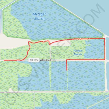
Name: Pintail Marsh trail, distance, elevation, map, profile, GPS track
Start: Veler Road, Lucas County, Ohio, 43445, United States (41.62885 -83.22841)
End: 12375, Veler Road, Lucas County, Ohio, 43445, United States (41.63158 -83.25065)
Coordinates: 41.62885 -83.25065 41.63735 -83.21495