Import a GPX file

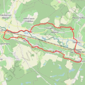
La Vallée de la Marne

  • Distance: 17.8 mi
  • Elevation gain: 619 m
  • Maximum elevation: 259 m
  • Elevation loss: 619 m
  • Minimum elevation: 62 m

Interactive trail map

Trail profile

  • Distance: 17.8 mi
  • Elevation gain: 619 m
  • Maximum elevation: 259 m
  • Elevation loss: 619 m
  • Minimum elevation: 62 m

About this trail

Gear up for your next adventure:

🧴Tick Removal Tools - Small, essential health tool for UK woodland and moorland
🛰️Handheld GPS Devices - Reliable GPS units for hiking and outdoor navigation
🔥Reusable Hand Warmers - Maintain dexterity in your fingers for precise map handling
🥫Expedition Meals - Lightweight, high-calorie nutrition for long-distance hikers
🧢Waterproof Hiking Hats - Keep the rain off your face while studying topographic maps

As an Amazon Associate, this site earns from qualifying purchases at no extra cost to you.