Make a donation
Gear up for your next adventure:
As an Amazon Associate, this site earns from qualifying purchases at no extra cost to you.
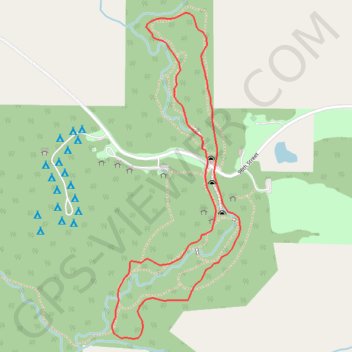
Maquoketa Caves Loop in Iowa
The Maquoketa Caves Loop offers a unique hiking experience in Iowa, where visitors can traverse both scenic landscapes and intriguing caves. Along the route, you'll encounter impressive rock formations, lush forests, and the tranquil Maquoketa River, all contributing to the trail's natural beauty. This relatively short and accessible loop is ideal for families, providing opportunities for exploration and adventure in a stunning outdoor setting. #Hiking #Loop #Cave #Forest #Nature
- Distance: 1.7 mi
- Elevation gain: 71 m
- Maximum elevation: 272 m
- Elevation loss: 71 m
- Minimum elevation: 225 m
Interactive trail map
Make a donation
Gear up for your next adventure:
As an Amazon Associate, this site earns from qualifying purchases at no extra cost to you.
Trail profile
- Distance: 1.7 mi
- Elevation gain: 71 m
- Maximum elevation: 272 m
- Elevation loss: 71 m
- Minimum elevation: 225 m
Make a donation
Gear up for your next adventure:
As an Amazon Associate, this site earns from qualifying purchases at no extra cost to you.
About this trail
Name: Maquoketa Caves Loop in Iowa trail, distance, elevation, map, profile, GPS track
Start: 98th Street, Jackson County, Iowa, United States (42.11893 -90.77340)
End: 98th Street, Jackson County, Iowa, United States (42.11893 -90.77340)
Coordinates: 42.11436 -90.77683 42.12309 -90.77219
Make a donation
Gear up for your next adventure:
As an Amazon Associate, this site earns from qualifying purchases at no extra cost to you.