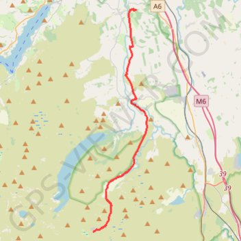
Mosedale Cottage to Lowther Castle hike
- Distance: 11.6 mi
- Elevation gain: 246 m
- Maximum elevation: 455 m
- Elevation loss: 462 m
- Minimum elevation: 171 m
- Moving time: 4 h 17 m
- Moving speed: 2.7 mph
- Maximum speed: 4.3 mph
- Total time: 4 h 47 m
- Global speed: 2.4 mph
Interactive trail map
Trail profile
- Distance: 11.6 mi
- Elevation gain: 246 m
- Maximum elevation: 455 m
- Elevation loss: 462 m
- Minimum elevation: 171 m
- Moving time: 4 h 17 m
- Moving speed: 2.7 mph
- Maximum speed: 4.3 mph
- Total time: 4 h 47 m
- Global speed: 2.4 mph
About this trail
Name: Mosedale Cottage to Lowther Castle hike trail, distance, elevation, map, profile, GPS track
Coordinates: 54.47838 -2.78105 54.60856 -2.72676
Topography: Westmorland and Furness topographic map, elevation, terrain
Other hiking, mountain biking, running and outdoor activity trails
Click on a trail to view its statistics, map and profile.
Staverly to Mosedale Cottage hike
United Kingdom > England > Westmorland and Furness > Staveley
Distance: 8.8 mi • Elevation gain: 595 m • Maximum elevation: 510 m