Make a donation
Gear up for your next adventure:
As an Amazon Associate, this site earns from qualifying purchases at no extra cost to you.
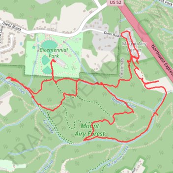
Mount Airy Forest Bicentennial Park Area
- Distance: 4.7 mi
- Elevation gain: 147 m
- Maximum elevation: 266 m
- Elevation loss: 148 m
- Minimum elevation: 195 m
- Moving time: 2 h 12 m
- Moving speed: 2.1 mph
- Maximum speed: 4.5 mph
- Total time: 3 h 11 m
- Global speed: 1.5 mph
Interactive trail map
Make a donation
Gear up for your next adventure:
As an Amazon Associate, this site earns from qualifying purchases at no extra cost to you.
Trail profile
- Distance: 4.7 mi
- Elevation gain: 147 m
- Maximum elevation: 266 m
- Elevation loss: 148 m
- Minimum elevation: 195 m
- Moving time: 2 h 12 m
- Moving speed: 2.1 mph
- Maximum speed: 4.5 mph
- Total time: 3 h 11 m
- Global speed: 1.5 mph
Make a donation
Gear up for your next adventure:
As an Amazon Associate, this site earns from qualifying purchases at no extra cost to you.
About this trail
Name: Mount Airy Forest Bicentennial Park Area trail, distance, elevation, map, profile, GPS track
Start: Nature Trail, Green Township, Hamilton County, Ohio, 45211, United States (39.16554 -84.58922)
End: Nature Trail, Green Township, Hamilton County, Ohio, 45211, United States (39.16556 -84.58916)
Coordinates: 39.15936 -84.59407 39.16793 -84.57811
Make a donation
Gear up for your next adventure:
As an Amazon Associate, this site earns from qualifying purchases at no extra cost to you.
Other hiking, mountain biking, running and outdoor activity trails
Click on a trail to view its statistics, map and profile.
Mount Airy Forest Maple Ridge Area
United States > Ohio > Hamilton County > Cincinnati
Distance: 3.4 mi • Elevation gain: 69 m • Maximum elevation: 272 m
Mount Airy Forest loop walk
United States > Ohio > Hamilton County > Cincinnati
Distance: 3.3 mi • Elevation gain: 111 m • Maximum elevation: 266 m