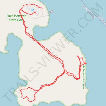
Lake Wateree State Park
- Distance: 2.5 mi
- Elevation gain: 10 m
- Maximum elevation: 76 m
- Elevation loss: 12 m
- Minimum elevation: 69 m
- Moving time: 1 h 1 m
- Moving speed: 2.5 mph
- Maximum speed: 5.9 mph
- Total time: 1 h 2 m
- Global speed: 2.4 mph
Interactive trail map
Trail profile
- Distance: 2.5 mi
- Elevation gain: 10 m
- Maximum elevation: 76 m
- Elevation loss: 12 m
- Minimum elevation: 69 m
- Moving time: 1 h 1 m
- Moving speed: 2.5 mph
- Maximum speed: 5.9 mph
- Total time: 1 h 2 m
- Global speed: 2.4 mph
About this trail
Name: Lake Wateree State Park trail, distance, elevation, map, profile, GPS track
Start: State Park Road, Fairfield County, South Carolina, 29180, United States (34.43299 -80.85948)
Coordinates: 34.42602 -80.86109 34.43376 -80.85465