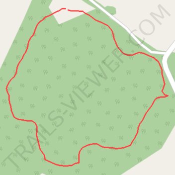
Unpaved walking path in nature reserve
- Distance: 0.5 mi
- Elevation gain: 6 m
- Maximum elevation: 166 m
- Elevation loss: 6 m
- Minimum elevation: 161 m
- Moving time: 11 m 30 s
- Moving speed: 2.8 mph
- Maximum speed: 4.1 mph
- Total time: 11 m 30 s
- Global speed: 2.8 mph
Interactive trail map
Trail profile
- Distance: 0.5 mi
- Elevation gain: 6 m
- Maximum elevation: 166 m
- Elevation loss: 6 m
- Minimum elevation: 161 m
- Moving time: 11 m 30 s
- Moving speed: 2.8 mph
- Maximum speed: 4.1 mph
- Total time: 11 m 30 s
- Global speed: 2.8 mph
About this trail
Name: Unpaved walking path in nature reserve trail, distance, elevation, map, profile, GPS track
Start: Llanyre, Newbridge on Wye, Powys, Wales, LD2 3SB, United Kingdom (52.20715 -3.44353)
End: Llanyre, Newbridge on Wye, Powys, Wales, LD2 3SB, United Kingdom (52.20713 -3.44348)
Coordinates: 52.20481 -3.44497 52.20715 -3.44104
Topography: Powys topographic map, elevation, terrain
Other hiking, mountain biking, running and outdoor activity trails
Click on a trail to view its statistics, map and profile.
The Headstock 500
United Kingdom > Wales > Newport > Newport
Distance: 300.4 mi • Elevation gain: 9,616 m • Maximum elevation: 691 m