Thank you for supporting this site ❤️
Make a donation
Make a donation
Gear up for your next adventure:
As an Amazon Associate, this site earns from qualifying purchases at no extra cost to you.
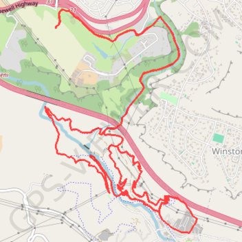
Giba Gorge Mountain Bike trail, Honey Trails
Bicycle Tour
- Distance: 14.5 mi
- Elevation gain: 755 m
- Maximum elevation: 643 m
- Elevation loss: 755 m
- Minimum elevation: 365 m
- Moving time: 1 h 44 m
- Moving speed: 8.3 mph
- Maximum speed: 21.9 mph
- Total time: 1 h 49 m
- Global speed: 7.9 mph
Interactive trail map
Thank you for supporting this site ❤️
Make a donation
Make a donation
Gear up for your next adventure:
As an Amazon Associate, this site earns from qualifying purchases at no extra cost to you.
Trail profile
- Distance: 14.5 mi
- Elevation gain: 755 m
- Maximum elevation: 643 m
- Elevation loss: 755 m
- Minimum elevation: 365 m
- Moving time: 1 h 44 m
- Moving speed: 8.3 mph
- Maximum speed: 21.9 mph
- Total time: 1 h 49 m
- Global speed: 7.9 mph
Thank you for supporting this site ❤️
Make a donation
Make a donation
Gear up for your next adventure:
As an Amazon Associate, this site earns from qualifying purchases at no extra cost to you.
About this trail
Name: Giba Gorge Mountain Bike trail, Honey Trails trail, distance, elevation, map, profile, GPS track
Coordinates: -29.82649 30.76128 -29.79977 30.78224
Thank you for supporting this site ❤️
Make a donation
Make a donation
Gear up for your next adventure:
As an Amazon Associate, this site earns from qualifying purchases at no extra cost to you.