Ship Peak Loop via Morning Ridge and Lost Oak trails
Turtleback Mountain Preserve
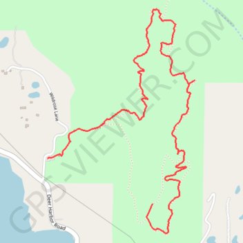
- Distance: 2.5 mi
- Elevation gain: 153 m
- Maximum elevation: 281 m
- Elevation loss: 280 m
- Minimum elevation: 41 m
- Moving time: 1 h 9 m
- Moving speed: 2.1 mph
- Maximum speed: 6.6 mph
- Total time: 1 h 14 m
- Global speed: 2.0 mph
Interactive trail map
Trail profile
- Distance: 2.5 mi
- Elevation gain: 153 m
- Maximum elevation: 281 m
- Elevation loss: 280 m
- Minimum elevation: 41 m
- Moving time: 1 h 9 m
- Moving speed: 2.1 mph
- Maximum speed: 6.6 mph
- Total time: 1 h 14 m
- Global speed: 2.0 mph
About this trail
Name: Ship Peak Loop via Morning Ridge and Lost Oak trails trail, distance, elevation, map, profile, GPS track
Start: Morning Ridge Trail, San Juan County, Washington, 98243, United States (48.63917 -122.96912)
Coordinates: 48.63765 -122.97724 48.64910 -122.96585