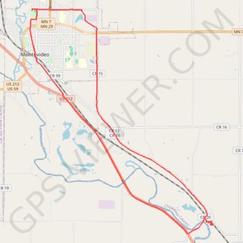
Montevideo
Bike ride
- Distance: 14.2 mi
- Elevation gain: 114 m
- Maximum elevation: 317 m
- Elevation loss: 115 m
- Minimum elevation: 281 m
- Moving time: 1 h 5 m
- Moving speed: 13.1 mph
- Maximum speed: 26.6 mph
- Total time: 1 h 9 m
- Global speed: 12.3 mph
Interactive trail map
Trail profile
- Distance: 14.2 mi
- Elevation gain: 114 m
- Maximum elevation: 317 m
- Elevation loss: 115 m
- Minimum elevation: 281 m
- Moving time: 1 h 5 m
- Moving speed: 13.1 mph
- Maximum speed: 26.6 mph
- Total time: 1 h 9 m
- Global speed: 12.3 mph
About this trail
Name: Montevideo trail, distance, elevation, map, profile, GPS track
Start: State Road, Wegdahl, Chippewa County, Minnesota, 56265, United States (44.89113 -95.64842)
End: State Road, Wegdahl, Chippewa County, Minnesota, 56265, United States (44.89107 -95.64846)
Coordinates: 44.88759 -95.72553 44.95630 -95.64681