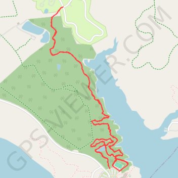
Deer Creek State Park
Trail Running
- Distance: 5.1 mi
- Elevation gain: 83 m
- Maximum elevation: 264 m
- Elevation loss: 83 m
- Minimum elevation: 246 m
- Moving time: 52 m 22 s
- Moving speed: 5.9 mph
- Maximum speed: 8.8 mph
- Total time: 52 m 22 s
- Global speed: 5.9 mph
Interactive trail map
Trail profile
- Distance: 5.1 mi
- Elevation gain: 83 m
- Maximum elevation: 264 m
- Elevation loss: 83 m
- Minimum elevation: 246 m
- Moving time: 52 m 22 s
- Moving speed: 5.9 mph
- Maximum speed: 8.8 mph
- Total time: 52 m 22 s
- Global speed: 5.9 mph
About this trail
Name: Deer Creek State Park trail, distance, elevation, map, profile, GPS track
Start: Rolling Hills Trail, Pickaway County, Ohio, United States (39.62332 -83.23706)
End: Van Horn Trail, Pickaway County, Ohio, United States (39.62295 -83.23653)
Coordinates: 39.62295 -83.24429 39.63726 -83.23549