Thank you for supporting this site ❤️
Make a donation
Make a donation
Gear up for your next adventure:
As an Amazon Associate, this site earns from qualifying purchases at no extra cost to you.
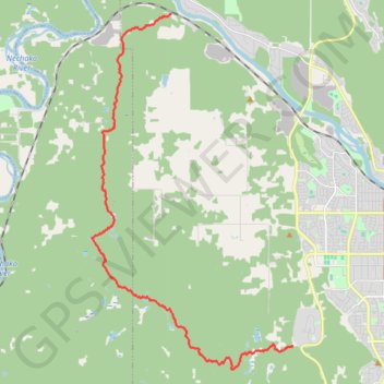
Cranbrook Hill Greenway Trail
#Hiking #MTB #Snowshoeing #Ski
- Distance: 11.2 mi
- Elevation gain: 201 m
- Maximum elevation: 840 m
- Elevation loss: 376 m
- Minimum elevation: 607 m
Interactive trail map
Thank you for supporting this site ❤️
Make a donation
Make a donation
Gear up for your next adventure:
As an Amazon Associate, this site earns from qualifying purchases at no extra cost to you.
Trail profile
- Distance: 11.2 mi
- Elevation gain: 201 m
- Maximum elevation: 840 m
- Elevation loss: 376 m
- Minimum elevation: 607 m
Thank you for supporting this site ❤️
Make a donation
Make a donation
Gear up for your next adventure:
As an Amazon Associate, this site earns from qualifying purchases at no extra cost to you.
About this trail
Name: Cranbrook Hill Greenway Trail trail, distance, elevation, map, profile, GPS track
Coordinates: 53.88094 -122.90747 53.97055 -122.82121
Thank you for supporting this site ❤️
Make a donation
Make a donation
Gear up for your next adventure:
As an Amazon Associate, this site earns from qualifying purchases at no extra cost to you.