Thank you for supporting this site ❤️
Make a donation
Make a donation
Gear up for your next adventure:
As an Amazon Associate, this site earns from qualifying purchases at no extra cost to you.
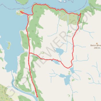
Castle Tioram
- Distance: 5.3 mi
- Elevation gain: 310 m
- Maximum elevation: 154 m
- Elevation loss: 310 m
- Minimum elevation: 0 m
- Moving time: 2 h 47 m
- Moving speed: 1.9 mph
- Maximum speed: 6.4 mph
- Total time: 3 h 7 m
- Global speed: 1.7 mph
Interactive trail map
Thank you for supporting this site ❤️
Make a donation
Make a donation
Gear up for your next adventure:
As an Amazon Associate, this site earns from qualifying purchases at no extra cost to you.
Trail profile
- Distance: 5.3 mi
- Elevation gain: 310 m
- Maximum elevation: 154 m
- Elevation loss: 310 m
- Minimum elevation: 0 m
- Moving time: 2 h 47 m
- Moving speed: 1.9 mph
- Maximum speed: 6.4 mph
- Total time: 3 h 7 m
- Global speed: 1.7 mph
Thank you for supporting this site ❤️
Make a donation
Make a donation
Gear up for your next adventure:
As an Amazon Associate, this site earns from qualifying purchases at no extra cost to you.
About this trail
Name: Castle Tioram trail, distance, elevation, map, profile, GPS track
Coordinates: 56.76522 -5.82808 56.78631 -5.80320
Topography: Highland topographic map, elevation, terrain
Thank you for supporting this site ❤️
Make a donation
Make a donation
Gear up for your next adventure:
As an Amazon Associate, this site earns from qualifying purchases at no extra cost to you.