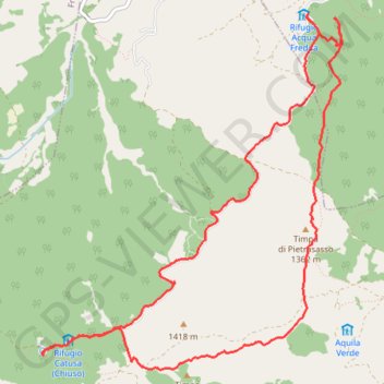
Da rifugio Acquafredda a sorgente Catusa
- Distance: 7.3 mi
- Elevation gain: 499 m
- Maximum elevation: 1,418 m
- Elevation loss: 497 m
- Minimum elevation: 1,066 m
- Moving time: 3 h 42 m
- Moving speed: 2.0 mph
- Maximum speed: 4.9 mph
- Total time: 5 h 11 m
- Global speed: 1.4 mph
Interactive trail map
Trail profile
- Distance: 7.3 mi
- Elevation gain: 499 m
- Maximum elevation: 1,418 m
- Elevation loss: 497 m
- Minimum elevation: 1,066 m
- Moving time: 3 h 42 m
- Moving speed: 2.0 mph
- Maximum speed: 4.9 mph
- Total time: 5 h 11 m
- Global speed: 1.4 mph
About this trail
Name: Da rifugio Acquafredda a sorgente Catusa trail, distance, elevation, map, profile, GPS track
Start: San Costantino Albanese, Potenza, Basilicata, Italy (40.01270 16.26634)
End: San Costantino Albanese, Potenza, Basilicata, Italy (40.01254 16.26606)
Coordinates: 39.98532 16.23948 40.01270 16.26970