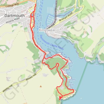
From Kingswear to Dartmouth
- Distance: 4.5 mi
- Elevation gain: 336 m
- Maximum elevation: 105 m
- Elevation loss: 336 m
- Minimum elevation: 0 m
- Moving time: 2 h 9 m
- Moving speed: 2.1 mph
- Maximum speed: 10.0 mph
- Total time: 2 h 26 m
- Global speed: 1.8 mph
Interactive trail map
Trail profile
- Distance: 4.5 mi
- Elevation gain: 336 m
- Maximum elevation: 105 m
- Elevation loss: 336 m
- Minimum elevation: 0 m
- Moving time: 2 h 9 m
- Moving speed: 2.1 mph
- Maximum speed: 10.0 mph
- Total time: 2 h 26 m
- Global speed: 1.8 mph
About this trail
Name: From Kingswear to Dartmouth trail, distance, elevation, map, profile, GPS track
Coordinates: 50.33364 -3.57860 50.35394 -3.56421
Topography: South Hams topographic map, elevation, terrain
Other hiking, mountain biking, running and outdoor activity trails
Click on a trail to view its statistics, map and profile.
Galmpton Stoke Fleming
United Kingdom > England > Torbay > Galmpton
Distance: 18.7 mi • Elevation gain: 815 m • Maximum elevation: 188 m