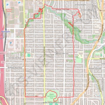
Maple Leaf & Thornton Creek Loop
- Distance: 4.8 mi
- Elevation gain: 119 m
- Maximum elevation: 135 m
- Elevation loss: 119 m
- Minimum elevation: 63 m
- Moving time: 54 m 53 s
- Moving speed: 5.2 mph
- Maximum speed: 9.4 mph
- Total time: 55 m 23 s
- Global speed: 5.2 mph
Interactive trail map
Trail profile
- Distance: 4.8 mi
- Elevation gain: 119 m
- Maximum elevation: 135 m
- Elevation loss: 119 m
- Minimum elevation: 63 m
- Moving time: 54 m 53 s
- Moving speed: 5.2 mph
- Maximum speed: 9.4 mph
- Total time: 55 m 23 s
- Global speed: 5.2 mph
About this trail
Name: Maple Leaf & Thornton Creek Loop trail, distance, elevation, map, profile, GPS track
Coordinates: 47.68965 -122.32322 47.70772 -122.30756
Other hiking, mountain biking, running and outdoor activity trails
Click on a trail to view its statistics, map and profile.
Maple Leaf & Kingfisher Natural Area Loop
United States > Washington > King County > Seattle
Distance: 3.0 mi • Elevation gain: 111 m • Maximum elevation: 136 m
Biking around Seattle
United States > Washington > King County > Seattle
Distance: 29.6 mi • Elevation gain: 407 m • Maximum elevation: 55 m