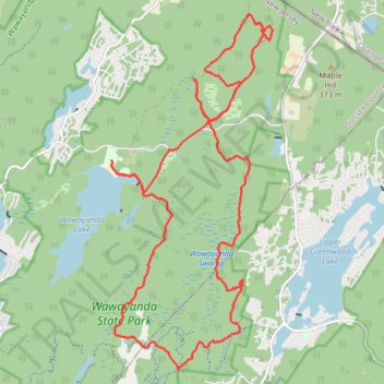
Swampy Wawayanda
- Distance: 16.0 mi
- Elevation gain: 375 m
- Maximum elevation: 399 m
- Elevation loss: 375 m
- Minimum elevation: 324 m
- Moving time: 2 h 39 m
- Moving speed: 6.0 mph
- Maximum speed: 19.9 mph
- Total time: 3 h 14 m
- Global speed: 4.9 mph
Interactive trail map
Trail profile
- Distance: 16.0 mi
- Elevation gain: 375 m
- Maximum elevation: 399 m
- Elevation loss: 375 m
- Minimum elevation: 324 m
- Moving time: 2 h 39 m
- Moving speed: 6.0 mph
- Maximum speed: 19.9 mph
- Total time: 3 h 14 m
- Global speed: 4.9 mph
About this trail
Name: Swampy Wawayanda trail, distance, elevation, map, profile, GPS track
Coordinates: 41.15686 -74.42869 41.21389 -74.39420
Other hiking, mountain biking, running and outdoor activity trails
Click on a trail to view its statistics, map and profile.
Pinwheel Vista via Appalachian Trail
United States > New Jersey > Sussex County > Vernon Township
Distance: 8.1 mi • Elevation gain: 414 m • Maximum elevation: 408 m
Nature Jim Tribute Ride
United States > New Jersey > Passaic County > West Milford > Moe
Wawayanda State Park
Distance: 12.3 mi • Elevation gain: 253 m • Maximum elevation: 432 m