Make a donation
Gear up for your next adventure:
As an Amazon Associate, this site earns from qualifying purchases at no extra cost to you.
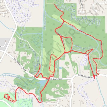
Allatoona Creek Gravel trails
- Distance: 11.2 mi
- Elevation gain: 122 m
- Maximum elevation: 283 m
- Elevation loss: 122 m
- Minimum elevation: 256 m
- Moving time: 1 h 13 m
- Moving speed: 9.1 mph
- Maximum speed: 19.7 mph
- Total time: 1 h 17 m
- Global speed: 8.6 mph
Interactive trail map
Make a donation
Gear up for your next adventure:
As an Amazon Associate, this site earns from qualifying purchases at no extra cost to you.
Trail profile
- Distance: 11.2 mi
- Elevation gain: 122 m
- Maximum elevation: 283 m
- Elevation loss: 122 m
- Minimum elevation: 256 m
- Moving time: 1 h 13 m
- Moving speed: 9.1 mph
- Maximum speed: 19.7 mph
- Total time: 1 h 17 m
- Global speed: 8.6 mph
Make a donation
Gear up for your next adventure:
As an Amazon Associate, this site earns from qualifying purchases at no extra cost to you.
About this trail
Name: Allatoona Creek Gravel trails trail, distance, elevation, map, profile, GPS track
Start: Pump Track, Cobb County, Georgia, 30101, United States (34.01709 -84.72678)
End: Pump Track, Cobb County, Georgia, 30101, United States (34.01716 -84.72677)
Coordinates: 34.01663 -84.72772 34.03390 -84.70680
Make a donation
Gear up for your next adventure:
As an Amazon Associate, this site earns from qualifying purchases at no extra cost to you.
Other hiking, mountain biking, running and outdoor activity trails
Click on a trail to view its statistics, map and profile.
Powder Springs, Allatoona trails, Dallas, Chatt Hills
United States > Georgia > Fayette County > Tyrone > Stop
Distance: 198.6 mi • Elevation gain: 3,805 m • Maximum elevation: 379 m
Allatoona Creek Park Wildcat Loop
United States > Georgia > Cobb County
Distance: 2.9 mi • Elevation gain: 85 m • Maximum elevation: 284 m