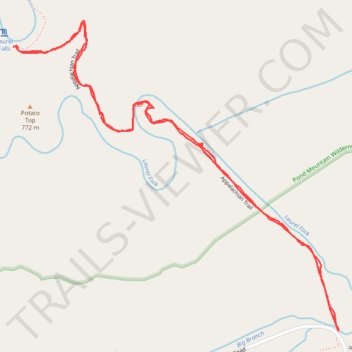
Laurel Fork Falls via Appalachian Trail
- Distance: 2.5 mi
- Elevation gain: 147 m
- Maximum elevation: 786 m
- Elevation loss: 147 m
- Minimum elevation: 665 m
- Moving time: 1 h 21 m
- Moving speed: 1.8 mph
- Maximum speed: 7.0 mph
- Total time: 1 h 43 m
- Global speed: 1.4 mph
Interactive trail map
Trail profile
- Distance: 2.5 mi
- Elevation gain: 147 m
- Maximum elevation: 786 m
- Elevation loss: 147 m
- Minimum elevation: 665 m
- Moving time: 1 h 21 m
- Moving speed: 1.8 mph
- Maximum speed: 7.0 mph
- Total time: 1 h 43 m
- Global speed: 1.4 mph
About this trail
Name: Laurel Fork Falls via Appalachian Trail trail, distance, elevation, map, profile, GPS track
Coordinates: 36.26429 -82.13461 36.27309 -82.12316
Other hiking, mountain biking, running and outdoor activity trails
Click on a trail to view its statistics, map and profile.
Comfort Suites Airport - Shady Valley Country Store
United States > Tennessee > Blount County > Alcoa > Farrport
146 mi, 2:28
Distance: 146.3 mi • Elevation gain: 3,292 m • Maximum elevation: 1,045 m