Make a donation
Gear up for your next adventure:
As an Amazon Associate, this site earns from qualifying purchases at no extra cost to you.
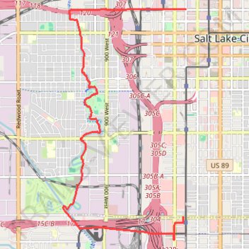
Ride from Downtown SLC to Ballpark along 200 S, JRT, and Parleys Trail
- Distance: 7.3 mi
- Elevation gain: 24 m
- Maximum elevation: 1,308 m
- Elevation loss: 37 m
- Minimum elevation: 1,290 m
- Moving time: 49 m 38 s
- Moving speed: 8.8 mph
- Maximum speed: 13.4 mph
- Total time: 51 m 43 s
- Global speed: 8.4 mph
Interactive trail map
Make a donation
Gear up for your next adventure:
As an Amazon Associate, this site earns from qualifying purchases at no extra cost to you.
Trail profile
- Distance: 7.3 mi
- Elevation gain: 24 m
- Maximum elevation: 1,308 m
- Elevation loss: 37 m
- Minimum elevation: 1,290 m
- Moving time: 49 m 38 s
- Moving speed: 8.8 mph
- Maximum speed: 13.4 mph
- Total time: 51 m 43 s
- Global speed: 8.4 mph
Make a donation
Gear up for your next adventure:
As an Amazon Associate, this site earns from qualifying purchases at no extra cost to you.
About this trail
Name: Ride from Downtown SLC to Ballpark along 200 S, JRT, and Parleys Trail trail, distance, elevation, map, profile, GPS track
Coordinates: 40.72118 -111.92771 40.76512 -111.89672
Make a donation
Gear up for your next adventure:
As an Amazon Associate, this site earns from qualifying purchases at no extra cost to you.
Other hiking, mountain biking, running and outdoor activity trails
Click on a trail to view its statistics, map and profile.
Bike Ride from Salt Lake City to Woods Cross via Jordan River Parkway
United States > Utah > Salt Lake County > Salt Lake City
Distance: 14.2 mi • Elevation gain: 44 m • Maximum elevation: 1,315 m
Pioneer Park Loop
United States > Utah > Salt Lake County > Salt Lake City
Distance: 0.5 mi • Elevation gain: 4 m • Maximum elevation: 1,300 m