Brownstone Canyon via Summerlin Stonebridge
- Distance: 10.2 mi
- Elevation gain: 528 m
- Maximum elevation: 1,512 m
- Elevation loss: 528 m
- Minimum elevation: 1,011 m
- Moving time: 3 h 32 m
- Moving speed: 2.9 mph
- Maximum speed: 3.8 mph
- Total time: 3 h 44 m
- Global speed: 2.7 mph
Interactive trail map
Trail profile
- Distance: 10.2 mi
- Elevation gain: 528 m
- Maximum elevation: 1,512 m
- Elevation loss: 528 m
- Minimum elevation: 1,011 m
- Moving time: 3 h 32 m
- Moving speed: 2.9 mph
- Maximum speed: 3.8 mph
- Total time: 3 h 44 m
- Global speed: 2.7 mph
About this trail
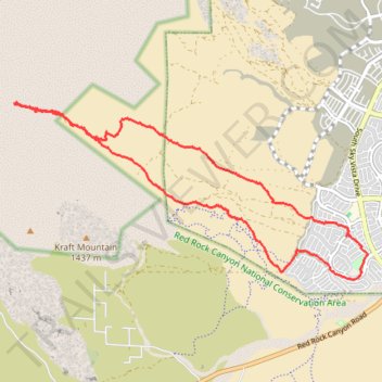
Name: Brownstone Canyon via Summerlin Stonebridge trail, distance, elevation, map, profile, GPS track
Coordinates: 36.15763 -115.43529 36.18519 -115.36696
Other hiking, mountain biking, running and outdoor activity trails
Click on a trail to view its statistics, map and profile.
Red Rock Legacy Trail
United States > Nevada > Clark County > Las Vegas
Distance: 2.4 mi • Elevation gain: 39 m • Maximum elevation: 1,017 m