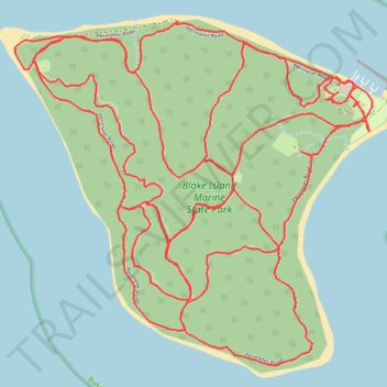
Blake Island Marine State Park trails
- Distance: 11.3 mi
- Elevation gain: 582 m
- Maximum elevation: 81 m
- Elevation loss: 581 m
- Minimum elevation: 1 m
- Moving time: 2 h 4 m
- Moving speed: 5.4 mph
- Maximum speed: 16.7 mph
- Total time: 2 h 10 m
- Global speed: 5.2 mph
Interactive trail map
Trail profile
- Distance: 11.3 mi
- Elevation gain: 582 m
- Maximum elevation: 81 m
- Elevation loss: 581 m
- Minimum elevation: 1 m
- Moving time: 2 h 4 m
- Moving speed: 5.4 mph
- Maximum speed: 16.7 mph
- Total time: 2 h 10 m
- Global speed: 5.2 mph
About this trail
Name: Blake Island Marine State Park trails trail, distance, elevation, map, profile, GPS track
Start: Perimeter Road, Kitsap County, Washington, United States (47.54237 -122.48316)
End: Perimeter Road, Kitsap County, Washington, United States (47.54220 -122.48281)
Coordinates: 47.53014 -122.50488 47.54504 -122.48192