Thank you for supporting this site ❤️
Make a donation
Make a donation
Gear up for your next adventure:
As an Amazon Associate, this site earns from qualifying purchases at no extra cost to you.
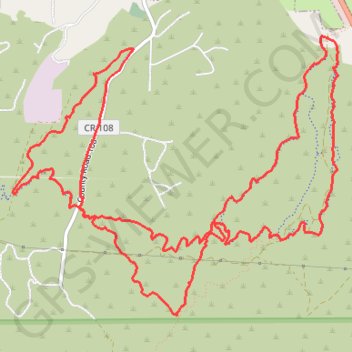
Riding solstice while I can. Salida, co
- Distance: 9.1 mi
- Elevation gain: 438 m
- Maximum elevation: 2,416 m
- Elevation loss: 437 m
- Minimum elevation: 2,154 m
- Moving time: 1 h 11 m
- Moving speed: 7.6 mph
- Maximum speed: 24.1 mph
- Total time: 1 h 27 m
- Global speed: 6.3 mph
Interactive trail map
Thank you for supporting this site ❤️
Make a donation
Make a donation
Gear up for your next adventure:
As an Amazon Associate, this site earns from qualifying purchases at no extra cost to you.
Trail profile
- Distance: 9.1 mi
- Elevation gain: 438 m
- Maximum elevation: 2,416 m
- Elevation loss: 437 m
- Minimum elevation: 2,154 m
- Moving time: 1 h 11 m
- Moving speed: 7.6 mph
- Maximum speed: 24.1 mph
- Total time: 1 h 27 m
- Global speed: 6.3 mph
Thank you for supporting this site ❤️
Make a donation
Make a donation
Gear up for your next adventure:
As an Amazon Associate, this site earns from qualifying purchases at no extra cost to you.
About this trail
Name: Riding solstice while I can. Salida, co trail, distance, elevation, map, profile, GPS track
Start: BLM 5672, Salida, Chaffee County, Colorado, United States (38.51066 -105.97987)
End: BLM 5672, Salida, Chaffee County, Colorado, United States (38.51058 -105.97974)
Coordinates: 38.49233 -106.01008 38.51295 -105.97940
Thank you for supporting this site ❤️
Make a donation
Make a donation
Gear up for your next adventure:
As an Amazon Associate, this site earns from qualifying purchases at no extra cost to you.