Import a GPX file

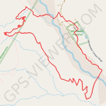
Whitewater Canyon Loop

Loop hike around the Whitewater River via the Pacific Crest Trail (PCT) and the Whitewater Canyon Road in the Sand to Snow National Monument. #Hiking #Loop #Canyon #River #Mountain #Nature #PCT

  • Distance: 3.7 mi
  • Elevation gain: 249 m
  • Maximum elevation: 842 m
  • Elevation loss: 250 m
  • Minimum elevation: 636 m

Interactive trail map

Trail profile

  • Distance: 3.7 mi
  • Elevation gain: 249 m
  • Maximum elevation: 842 m
  • Elevation loss: 250 m
  • Minimum elevation: 636 m

About this trail

Gear up for your next adventure:

🛌Sleeping Mats - Insulated mats for comfortable outdoor sleeping
🧘Folding Sit Mats - Dry and warm seat for map-reading breaks on damp ground
🪢Paracord - Multi-purpose cord for camping and survival
👖Convertible Hiking Trousers - Versatile zip-off pants for changing mountain weather conditions
🧥Softshell Jackets - Breathable jackets for active outdoor use

As an Amazon Associate, this site earns from qualifying purchases at no extra cost to you.