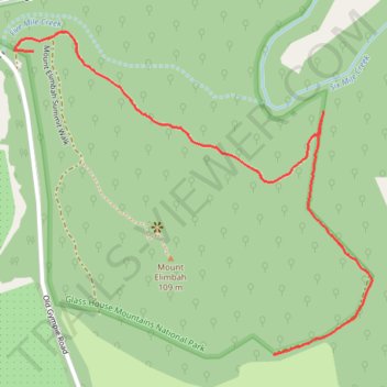
Mount Elimbah Fire Track in Glass House Mountains National Park
- Distance: 1.2 mi
- Elevation gain: 32 m
- Maximum elevation: 42 m
- Elevation loss: 19 m
- Minimum elevation: 19 m
- Moving time: 12 m 28 s
- Moving speed: 5.9 mph
- Maximum speed: 11.4 mph
- Total time: 14 m 5 s
- Global speed: 5.2 mph
Interactive trail map
Trail profile
- Distance: 1.2 mi
- Elevation gain: 32 m
- Maximum elevation: 42 m
- Elevation loss: 19 m
- Minimum elevation: 19 m
- Moving time: 12 m 28 s
- Moving speed: 5.9 mph
- Maximum speed: 11.4 mph
- Total time: 14 m 5 s
- Global speed: 5.2 mph
About this trail
Name: Mount Elimbah Fire Track in Glass House Mountains National Park trail, distance, elevation, map, profile, GPS track
Start: Mount Elimbah Summit Walk, Brisbane, Queensland, 4516, Australia (-27.00891 152.92374)
End: Mount Elimbah Summit Walk, Brisbane, Queensland, 4516, Australia (-27.01574 152.92991)
Coordinates: -27.01577 152.92326 -27.00846 152.93234
Other hiking, mountain biking, running and outdoor activity trails
Click on a trail to view its statistics, map and profile.