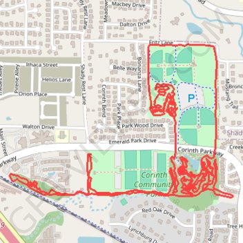
Corinth Community Park MTB
Interactive trail map
Trail profile
- Distance: 7.4 mi
- Elevation gain: 35 m
- Maximum elevation: 179 m
- Elevation loss: 35 m
- Minimum elevation: 167 m
- Moving time: 49 m 5 s
- Moving speed: 9.1 mph
- Maximum speed: 16.6 mph
- Total time: 49 m 5 s
- Global speed: 9.1 mph
About this trail
Name: Corinth Community Park MTB trail, distance, elevation, map, profile, GPS track
Start: Corinth Parkway, Corinth, Denton County, Texas, 76206, United States (33.15271 -97.04696)
End: Corinth Parkway, Corinth, Denton County, Texas, 76206, United States (33.15270 -97.04697)
Coordinates: 33.15060 -97.05766 33.15892 -97.04315