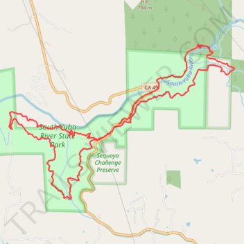
Independence Trail / South Yuba River
- Distance: 8.2 mi
- Elevation gain: 690 m
- Maximum elevation: 468 m
- Elevation loss: 709 m
- Minimum elevation: 325 m
- Moving time: 3 h 36 m
- Moving speed: 2.3 mph
- Maximum speed: 5.5 mph
- Total time: 5 h 12 m
- Global speed: 1.6 mph
Interactive trail map
Trail profile
- Distance: 8.2 mi
- Elevation gain: 690 m
- Maximum elevation: 468 m
- Elevation loss: 709 m
- Minimum elevation: 325 m
- Moving time: 3 h 36 m
- Moving speed: 2.3 mph
- Maximum speed: 5.5 mph
- Total time: 5 h 12 m
- Global speed: 1.6 mph
About this trail
Name: Independence Trail / South Yuba River trail, distance, elevation, map, profile, GPS track
Start: Independence Trail, Nevada County, California, United States (39.29157 -121.09718)
End: CA 49, Nevada County, California, United States (39.29265 -121.09603)
Coordinates: 39.28263 -121.11498 39.30315 -121.07608