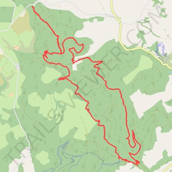
Brechfa Forest MTB Loop Ride
- Distance: 13.7 mi
- Elevation gain: 661 m
- Maximum elevation: 352 m
- Elevation loss: 661 m
- Minimum elevation: 103 m
- Moving time: 1 h 33 m
- Moving speed: 8.8 mph
- Maximum speed: 24.3 mph
- Total time: 2 h 3 m
- Global speed: 6.7 mph
Interactive trail map
Trail profile
- Distance: 13.7 mi
- Elevation gain: 661 m
- Maximum elevation: 352 m
- Elevation loss: 661 m
- Minimum elevation: 103 m
- Moving time: 1 h 33 m
- Moving speed: 8.8 mph
- Maximum speed: 24.3 mph
- Total time: 2 h 3 m
- Global speed: 6.7 mph
About this trail
Name: Brechfa Forest MTB Loop Ride trail, distance, elevation, map, profile, GPS track
Coordinates: 51.98889 -4.11339 52.03337 -4.06384
Topography: Carmarthenshire topographic map, elevation, terrain