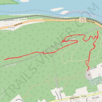
Cove Mountain Preserve trails
- Distance: 6.0 mi
- Elevation gain: 390 m
- Maximum elevation: 372 m
- Elevation loss: 389 m
- Minimum elevation: 175 m
- Moving time: 2 h 28 m
- Moving speed: 2.4 mph
- Maximum speed: 4.8 mph
- Total time: 2 h 33 m
- Global speed: 2.3 mph
Interactive trail map
Trail profile
- Distance: 6.0 mi
- Elevation gain: 390 m
- Maximum elevation: 372 m
- Elevation loss: 389 m
- Minimum elevation: 175 m
- Moving time: 2 h 28 m
- Moving speed: 2.4 mph
- Maximum speed: 4.8 mph
- Total time: 2 h 33 m
- Global speed: 2.3 mph
About this trail
Name: Cove Mountain Preserve trails trail, distance, elevation, map, profile, GPS track
Start: Sylvan Street, Marysville, Perry County, Pennsylvania, 17053, United States (40.34702 -76.93835)
End: Sylvan Street, Marysville, Perry County, Pennsylvania, 17053, United States (40.34708 -76.93838)
Coordinates: 40.34702 -76.96001 40.35499 -76.93569
Other hiking, mountain biking, running and outdoor activity trails
Click on a trail to view its statistics, map and profile.
Cove Mountain Preserve
United States > Pennsylvania > Perry County > Marysville
Distance: 3.4 mi • Elevation gain: 213 m • Maximum elevation: 340 m
Cove Mountain Preserve Trail
United States > Pennsylvania > Perry County > Marysville
Distance: 4.8 mi • Elevation gain: 359 m • Maximum elevation: 340 m