Thank you for supporting this site ❤️
Make a donation
Make a donation
Gear up for your next adventure:
As an Amazon Associate, this site earns from qualifying purchases at no extra cost to you.
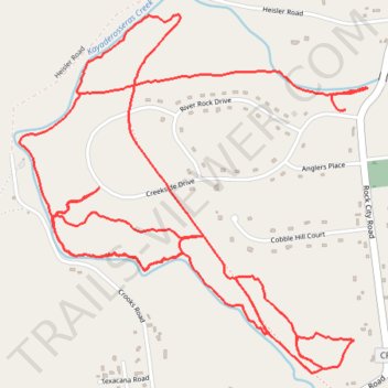
Boice Family Park - Town of Milton, NY
- Distance: 5.8 mi
- Elevation gain: 104 m
- Maximum elevation: 145 m
- Elevation loss: 119 m
- Minimum elevation: 116 m
Interactive trail map
Thank you for supporting this site ❤️
Make a donation
Make a donation
Gear up for your next adventure:
As an Amazon Associate, this site earns from qualifying purchases at no extra cost to you.
Trail profile
- Distance: 5.8 mi
- Elevation gain: 104 m
- Maximum elevation: 145 m
- Elevation loss: 119 m
- Minimum elevation: 116 m
Thank you for supporting this site ❤️
Make a donation
Make a donation
Gear up for your next adventure:
As an Amazon Associate, this site earns from qualifying purchases at no extra cost to you.
About this trail
Name: Boice Family Park - Town of Milton, NY trail, distance, elevation, map, profile, GPS track
Coordinates: 43.04186 -73.93609 43.05494 -73.91870
Thank you for supporting this site ❤️
Make a donation
Make a donation
Gear up for your next adventure:
As an Amazon Associate, this site earns from qualifying purchases at no extra cost to you.
Other hiking, mountain biking, running and outdoor activity trails
Click on a trail to view its statistics, map and profile.