Thank you for supporting this site ❤️
Make a donation
Make a donation
Gear up for your next adventure:
As an Amazon Associate, this site earns from qualifying purchases at no extra cost to you.
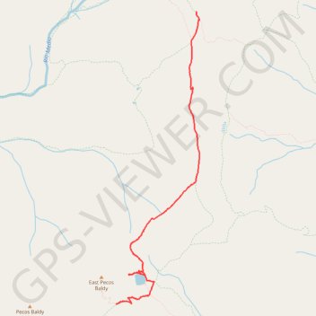
2024-06-12 06:36:59 001
- Distance: 4.2 mi
- Elevation gain: 202 m
- Maximum elevation: 3,638 m
- Elevation loss: 292 m
- Minimum elevation: 3,491 m
- Moving time: 2 h 34 m
- Moving speed: 1.6 mph
- Maximum speed: 3.0 mph
- Total time: 3 h 56 m
- Global speed: 1.1 mph
Interactive trail map
Thank you for supporting this site ❤️
Make a donation
Make a donation
Gear up for your next adventure:
As an Amazon Associate, this site earns from qualifying purchases at no extra cost to you.
Trail profile
- Distance: 4.2 mi
- Elevation gain: 202 m
- Maximum elevation: 3,638 m
- Elevation loss: 292 m
- Minimum elevation: 3,491 m
- Moving time: 2 h 34 m
- Moving speed: 1.6 mph
- Maximum speed: 3.0 mph
- Total time: 3 h 56 m
- Global speed: 1.1 mph
Thank you for supporting this site ❤️
Make a donation
Make a donation
Gear up for your next adventure:
As an Amazon Associate, this site earns from qualifying purchases at no extra cost to you.
About this trail
Name: 2024-06-12 06:36:59 001 trail, distance, elevation, map, profile, GPS track
Start: East Pecos Baldy Summit Trail (275), Mora County, New Mexico, United States (35.90913 -105.65141)
End: Skyline Trail (251), Mora County, New Mexico, United States (35.94945 -105.63784)
Coordinates: 35.90913 -105.65141 35.94945 -105.63715
Thank you for supporting this site ❤️
Make a donation
Make a donation
Gear up for your next adventure:
As an Amazon Associate, this site earns from qualifying purchases at no extra cost to you.