Pobijenik
- Distance: 7.3 mi
- Elevation gain: 514 m
- Maximum elevation: 1,420 m
- Elevation loss: 515 m
- Minimum elevation: 1,061 m
- Moving time: 3 h 18 m
- Moving speed: 2.2 mph
- Maximum speed: 4.3 mph
- Total time: 5 h 13 m
- Global speed: 1.4 mph
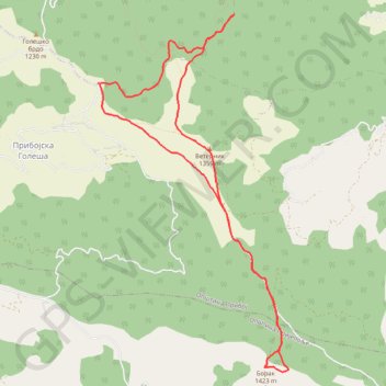
Interactive trail map
Trail profile
- Distance: 7.3 mi
- Elevation gain: 514 m
- Maximum elevation: 1,420 m
- Elevation loss: 515 m
- Minimum elevation: 1,061 m
- Moving time: 3 h 18 m
- Moving speed: 2.2 mph
- Maximum speed: 4.3 mph
- Total time: 5 h 13 m
- Global speed: 1.4 mph
About this trail
Name: Pobijenik trail, distance, elevation, map, profile, GPS track
Coordinates: 43.47866 19.52359 43.51399 19.54955
Other hiking, mountain biking, running and outdoor activity trails
Click on a trail to view its statistics, map and profile.
2022_Yu
Slovenia > Ajdovščina > Žapuže
Distance: 1,526.9 mi • Elevation gain: 32,048 m • Maximum elevation: 1,950 m
Lisa stena
Serbia > Central Serbia > Zlatibor Administrative District > Priboj Municipality > Priboj
Distance: 10.8 mi • Elevation gain: 914 m • Maximum elevation: 1,182 m