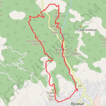
Sobina -Borino brdo - Krstilovica - Srednja cuka - Mala reka...
- Distance: 9.6 mi
- Elevation gain: 883 m
- Maximum elevation: 1,150 m
- Elevation loss: 889 m
- Minimum elevation: 503 m
- Moving time: 5 h 7 m
- Moving speed: 1.9 mph
- Maximum speed: 4.0 mph
- Total time: 5 h 35 m
- Global speed: 1.7 mph
Interactive trail map
Trail profile
- Distance: 9.6 mi
- Elevation gain: 883 m
- Maximum elevation: 1,150 m
- Elevation loss: 889 m
- Minimum elevation: 503 m
- Moving time: 5 h 7 m
- Moving speed: 1.9 mph
- Maximum speed: 4.0 mph
- Total time: 5 h 35 m
- Global speed: 1.7 mph
About this trail
Name: Sobina -Borino brdo - Krstilovica - Srednja cuka - Mala reka... trail, distance, elevation, map, profile, GPS track
Coordinates: 42.55640 21.86782 42.60050 21.89784
Other hiking, mountain biking, running and outdoor activity trails
Click on a trail to view its statistics, map and profile.
2022_Yu
Slovenia > Ajdovščina > Žapuže
Distance: 1,526.9 mi • Elevation gain: 32,048 m • Maximum elevation: 1,950 m