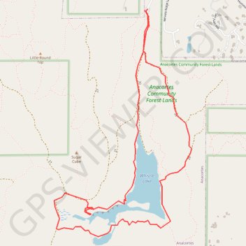
Whistle Lake Loop
Loop hike around Whistle Lake via Gerry Wallrath Trail, Toot Swamp and Kenny Oaks Trail in the Anacortes Community Forest Lands on the Fidalgo Island. #Hiking #Loop #Lake #Forest #Nature
- Distance: 4.1 mi
- Elevation gain: 171 m
- Maximum elevation: 181 m
- Elevation loss: 172 m
- Minimum elevation: 126 m
- Moving time: 1 h 50 m
- Moving speed: 2.2 mph
- Maximum speed: 5.7 mph
- Total time: 2 h 16 m
- Global speed: 1.8 mph
Interactive trail map
Trail profile
- Distance: 4.1 mi
- Elevation gain: 171 m
- Maximum elevation: 181 m
- Elevation loss: 172 m
- Minimum elevation: 126 m
- Moving time: 1 h 50 m
- Moving speed: 2.2 mph
- Maximum speed: 5.7 mph
- Total time: 2 h 16 m
- Global speed: 1.8 mph
About this trail
Name: Whistle Lake Loop trail, distance, elevation, map, profile, GPS track
Start: 20, Anacortes, Skagit County, Washington, 98221, United States (48.47347 -122.60537)
End: 20, Anacortes, Skagit County, Washington, 98221, United States (48.47362 -122.60528)
Coordinates: 48.45614 -122.61599 48.47367 -122.60005