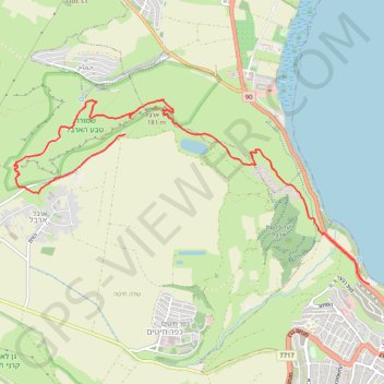
Mount Arbel
- Distance: 6.0 mi
- Elevation gain: 778 m
- Maximum elevation: 163 m
- Elevation loss: 437 m
- Minimum elevation: -205 m
Interactive trail map
Trail profile
- Distance: 6.0 mi
- Elevation gain: 778 m
- Maximum elevation: 163 m
- Elevation loss: 437 m
- Minimum elevation: -205 m
About this trail
Name: Mount Arbel trail, distance, elevation, map, profile, GPS track
Start: 90, David Remez, Tiberias, Kinneret Subdistrict, North District, 1427943, Israel (32.80478 35.52878)
Coordinates: 32.80478 35.48077 32.82572 35.52878
Other hiking, mountain biking, running and outdoor activity trails
Click on a trail to view its statistics, map and profile.