ASP QUARRY
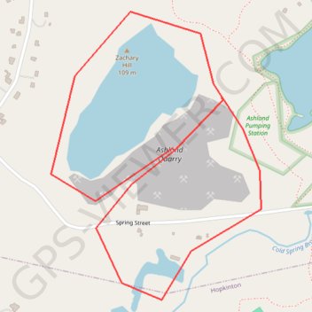
Quarry Route in Ashland
- Distance: 1.8 mi
- Elevation gain: 41 m
- Maximum elevation: 105 m
- Elevation loss: 38 m
- Minimum elevation: 74 m
Interactive trail map
Trail profile
- Distance: 1.8 mi
- Elevation gain: 41 m
- Maximum elevation: 105 m
- Elevation loss: 38 m
- Minimum elevation: 74 m
About this trail
Name: ASP QUARRY trail, distance, elevation, map, profile, GPS track
End: Spring Street, Ashland, Middlesex County, Massachusetts, 01721, United States (42.23443 -71.47349)
Coordinates: 42.22930 -71.47933 42.23663 -71.47212
Other hiking, mountain biking, running and outdoor activity trails
Click on a trail to view its statistics, map and profile.
Loop in Eastern Mass involving various rail trails
United States > Massachusetts > Middlesex County > Newton
Distance: 126.6 mi • Elevation gain: 1,940 m • Maximum elevation: 194 m
Cambridge - Providence Express
United States > Massachusetts > Middlesex County > Cambridge
Alewife -> Providence
Distance: 63.2 mi • Elevation gain: 961 m • Maximum elevation: 107 m
Dedham-Providence-Dedham
United States > Massachusetts > Norfolk County > Dedham
Distance: 126.0 mi • Elevation gain: 1,811 m • Maximum elevation: 167 m