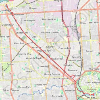
Port Adelaide to city
#Bike
- Distance: 8.6 mi
- Elevation gain: 53 m
- Maximum elevation: 36 m
- Elevation loss: 26 m
- Minimum elevation: 6 m
Interactive trail map
Trail profile
- Distance: 8.6 mi
- Elevation gain: 53 m
- Maximum elevation: 36 m
- Elevation loss: 26 m
- Minimum elevation: 6 m
About this trail
Name: Port Adelaide to city trail, distance, elevation, map, profile, GPS track
Coordinates: -34.91996 138.50841 -34.84387 138.59679
Other hiking, mountain biking, running and outdoor activity trails
Click on a trail to view its statistics, map and profile.
Dry Creek Trail
Australia > South Australia > Adelaide
Distance: 14.0 mi • Elevation gain: 263 m • Maximum elevation: 204 m