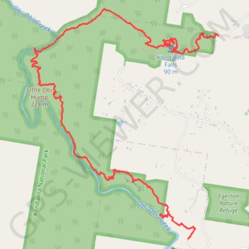
Lake Baroon - Kondalilla Falls
Kondalilla National Park. #Hiking #Baroon #Kondalilla
- Distance: 6.8 mi
- Elevation gain: 582 m
- Maximum elevation: 341 m
- Elevation loss: 460 m
- Minimum elevation: 125 m
Interactive trail map
Trail profile
- Distance: 6.8 mi
- Elevation gain: 582 m
- Maximum elevation: 341 m
- Elevation loss: 460 m
- Minimum elevation: 125 m
About this trail
Name: Lake Baroon - Kondalilla Falls trail, distance, elevation, map, profile, GPS track
Coordinates: -26.69716 152.84524 -26.66789 152.87189
Other hiking, mountain biking, running and outdoor activity trails
Click on a trail to view its statistics, map and profile.
Imbil Jimna Kenilworth loop
Australia > Queensland > Tewantin
Distance: 134.2 mi • Elevation gain: 3,884 m • Maximum elevation: 822 m
Kondalilla Falls - Rock Pools Loop
Australia > Queensland > Sunshine Coast Regional
Kondalilla National Park. #Hiking #Loop #Kondalilla
Distance: 2.9 mi • Elevation gain: 266 m • Maximum elevation: 340 m
Lake Baroon - Kondalilla Falls
Australia > Queensland > Sunshine Coast Regional
Kondalilla National Park. #Hiking #Baroon #Kondalilla
Distance: 6.0 mi • Elevation gain: 499 m • Maximum elevation: 339 m