Tzeelim Challenge
אתגר צאלים: שמונה מעלות של קניון צאלים
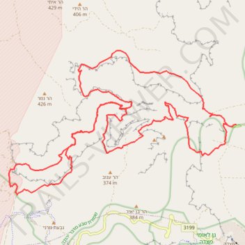
- Distance: 25.2 mi
- Elevation gain: 2,409 m
- Maximum elevation: 356 m
- Elevation loss: 2,408 m
- Minimum elevation: -293 m
- Moving time: 13 h 15 m
- Moving speed: 1.9 mph
- Maximum speed: 2.8 mph
- Total time: 13 h 15 m
- Global speed: 1.9 mph
Interactive trail map
Trail profile
- Distance: 25.2 mi
- Elevation gain: 2,409 m
- Maximum elevation: 356 m
- Elevation loss: 2,408 m
- Minimum elevation: -293 m
- Moving time: 13 h 15 m
- Moving speed: 1.9 mph
- Maximum speed: 2.8 mph
- Total time: 13 h 15 m
- Global speed: 1.9 mph
About this trail
Name: Tzeelim Challenge trail, distance, elevation, map, profile, GPS track
Coordinates: 31.33060 35.27554 31.37451 35.35610
Other hiking, mountain biking, running and outdoor activity trails
Click on a trail to view its statistics, map and profile.
7 Ascents in the Dead Sea
Israel > South District > Tamar Regional Council
שבע מעלות בים המלח: קו עליות דרך עשאל, משמר, צאלים ומצדה
Distance: 19.4 mi • Elevation gain: 2,112 m • Maximum elevation: 275 m
Tzeelim - Mishmar
Israel > South District > Tamar Regional Council
צאלים ומשמר: שלוש מעלות טכנים, שני קניונים ובמת מדבר אחת
Distance: 12.4 mi • Elevation gain: 1,047 m • Maximum elevation: 294 m
Tzeelim Circle
Israel > South District > Tamar Regional Council
סובב צאלים: מסלול יפיפה דרך בריכת צפירה ומעלה ענבה
Distance: 15.6 mi • Elevation gain: 1,203 m • Maximum elevation: 369 m