Thank you for supporting this site ❤️
Make a donation
Make a donation
Gear up for your next adventure:
As an Amazon Associate, this site earns from qualifying purchases at no extra cost to you.
Magnolia Gravel Galore
- Distance: 57.4 mi
- Elevation gain: 1,476 m
- Maximum elevation: 379 m
- Elevation loss: 1,475 m
- Minimum elevation: 277 m
- Moving time: 3 h 43 m
- Moving speed: 15.4 mph
- Maximum speed: 38.7 mph
- Total time: 3 h 44 m
- Global speed: 15.3 mph
Interactive trail map
Thank you for supporting this site ❤️
Make a donation
Make a donation
Gear up for your next adventure:
As an Amazon Associate, this site earns from qualifying purchases at no extra cost to you.
Trail profile
- Distance: 57.4 mi
- Elevation gain: 1,476 m
- Maximum elevation: 379 m
- Elevation loss: 1,475 m
- Minimum elevation: 277 m
- Moving time: 3 h 43 m
- Moving speed: 15.4 mph
- Maximum speed: 38.7 mph
- Total time: 3 h 44 m
- Global speed: 15.3 mph
Thank you for supporting this site ❤️
Make a donation
Make a donation
Gear up for your next adventure:
As an Amazon Associate, this site earns from qualifying purchases at no extra cost to you.
About this trail
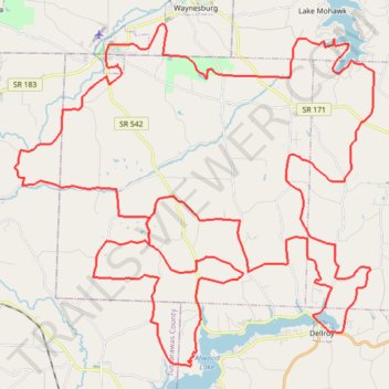
Name: Magnolia Gravel Galore trail, distance, elevation, map, profile, GPS track
Start: Morges Road, Magnolia, Carroll County, Ohio, 44643, United States (40.64774 -81.29324)
End: Morges Road, Magnolia, Carroll County, Ohio, 44643, United States (40.64757 -81.29324)
Coordinates: 40.54265 -81.34058 40.66253 -81.17553
Thank you for supporting this site ❤️
Make a donation
Make a donation
Gear up for your next adventure:
As an Amazon Associate, this site earns from qualifying purchases at no extra cost to you.