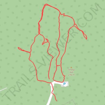
Sheep Hill Park
- Distance: 1.3 mi
- Elevation gain: 66 m
- Maximum elevation: 285 m
- Elevation loss: 62 m
- Minimum elevation: 256 m
- Moving time: 30 m 29 s
- Moving speed: 2.6 mph
- Maximum speed: 6.0 mph
- Total time: 37 m 13 s
- Global speed: 2.1 mph
Interactive trail map
Trail profile
- Distance: 1.3 mi
- Elevation gain: 66 m
- Maximum elevation: 285 m
- Elevation loss: 62 m
- Minimum elevation: 256 m
- Moving time: 30 m 29 s
- Moving speed: 2.6 mph
- Maximum speed: 6.0 mph
- Total time: 37 m 13 s
- Global speed: 2.1 mph
About this trail
Name: Sheep Hill Park trail, distance, elevation, map, profile, GPS track
Start: Ross Drive, Boonton Township, Morris County, New Jersey, 07005, United States (40.91826 -74.40670)
End: Ross Drive, Boonton Township, Morris County, New Jersey, 07005, United States (40.91909 -74.40708)
Coordinates: 40.91826 -74.40864 40.92193 -74.40520