Thank you for supporting this site ❤️
Make a donation
Make a donation
Gear up for your next adventure:
As an Amazon Associate, this site earns from qualifying purchases at no extra cost to you.
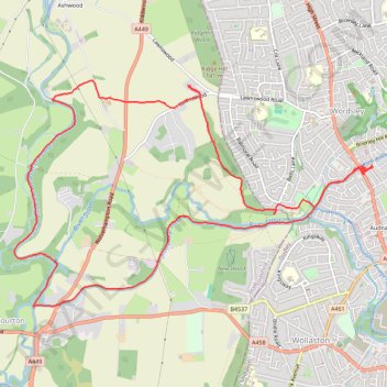
Canal walk public foot paths - Wordsley
- Distance: 8.1 mi
- Elevation gain: 120 m
- Maximum elevation: 115 m
- Elevation loss: 120 m
- Minimum elevation: 54 m
- Moving time: 2 h 55 m
- Moving speed: 2.8 mph
- Maximum speed: 6.9 mph
- Total time: 3 h 49 m
- Global speed: 2.1 mph
Interactive trail map
Thank you for supporting this site ❤️
Make a donation
Make a donation
Gear up for your next adventure:
As an Amazon Associate, this site earns from qualifying purchases at no extra cost to you.
Trail profile
- Distance: 8.1 mi
- Elevation gain: 120 m
- Maximum elevation: 115 m
- Elevation loss: 120 m
- Minimum elevation: 54 m
- Moving time: 2 h 55 m
- Moving speed: 2.8 mph
- Maximum speed: 6.9 mph
- Total time: 3 h 49 m
- Global speed: 2.1 mph
Thank you for supporting this site ❤️
Make a donation
Make a donation
Gear up for your next adventure:
As an Amazon Associate, this site earns from qualifying purchases at no extra cost to you.
About this trail
Name: Canal walk public foot paths - Wordsley trail, distance, elevation, map, profile, GPS track
Coordinates: 52.46371 -2.20842 52.48397 -2.15577
Topography: England topographic map, elevation, terrain
Thank you for supporting this site ❤️
Make a donation
Make a donation
Gear up for your next adventure:
As an Amazon Associate, this site earns from qualifying purchases at no extra cost to you.