Thank you for supporting this site ❤️
Make a donation
Make a donation
Gear up for your next adventure:
As an Amazon Associate, this site earns from qualifying purchases at no extra cost to you.
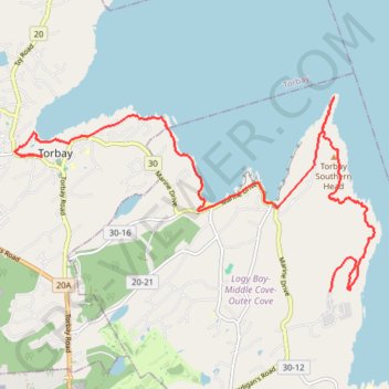
East Coast Trail - Silver Mine Cobbler Path
#Hiking #Newfoundland #Atlantic
- Distance: 9.2 mi
- Elevation gain: 514 m
- Maximum elevation: 189 m
- Elevation loss: 621 m
- Minimum elevation: -1 m
Interactive trail map
Thank you for supporting this site ❤️
Make a donation
Make a donation
Gear up for your next adventure:
As an Amazon Associate, this site earns from qualifying purchases at no extra cost to you.
Trail profile
- Distance: 9.2 mi
- Elevation gain: 514 m
- Maximum elevation: 189 m
- Elevation loss: 621 m
- Minimum elevation: -1 m
Thank you for supporting this site ❤️
Make a donation
Make a donation
Gear up for your next adventure:
As an Amazon Associate, this site earns from qualifying purchases at no extra cost to you.
About this trail
Name: East Coast Trail - Silver Mine Cobbler Path trail, distance, elevation, map, profile, GPS track
Coordinates: 47.63841 -52.73533 47.66528 -52.66147
Thank you for supporting this site ❤️
Make a donation
Make a donation
Gear up for your next adventure:
As an Amazon Associate, this site earns from qualifying purchases at no extra cost to you.