Thank you for supporting this site ❤️
Make a donation
Make a donation
Gear up for your next adventure:
As an Amazon Associate, this site earns from qualifying purchases at no extra cost to you.
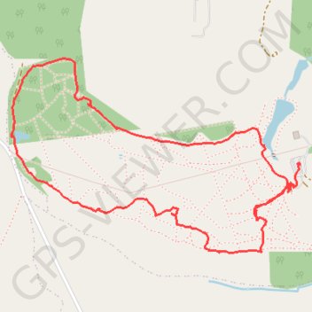
Yorkshire Arboretum Loop
Loop hike from the Yorkshire Arboretum Visitor Center in the Howardian Hills National Landscape. #Hiking #Loop #Nature #Forest #Lake #Park
- Distance: 2.4 mi
- Elevation gain: 49 m
- Maximum elevation: 103 m
- Elevation loss: 45 m
- Minimum elevation: 77 m
- Moving time: 1 h 20 m
- Moving speed: 1.8 mph
- Maximum speed: 4.1 mph
- Total time: 2 h 8 m
- Global speed: 1.1 mph
Interactive trail map
Thank you for supporting this site ❤️
Make a donation
Make a donation
Gear up for your next adventure:
As an Amazon Associate, this site earns from qualifying purchases at no extra cost to you.
Trail profile
- Distance: 2.4 mi
- Elevation gain: 49 m
- Maximum elevation: 103 m
- Elevation loss: 45 m
- Minimum elevation: 77 m
- Moving time: 1 h 20 m
- Moving speed: 1.8 mph
- Maximum speed: 4.1 mph
- Total time: 2 h 8 m
- Global speed: 1.1 mph
Thank you for supporting this site ❤️
Make a donation
Make a donation
Gear up for your next adventure:
As an Amazon Associate, this site earns from qualifying purchases at no extra cost to you.
About this trail
Name: Yorkshire Arboretum Loop trail, distance, elevation, map, profile, GPS track
Coordinates: 54.11624 -0.93700 54.12248 -0.92119
Topography: North Yorkshire topographic map, elevation, terrain
Thank you for supporting this site ❤️
Make a donation
Make a donation
Gear up for your next adventure:
As an Amazon Associate, this site earns from qualifying purchases at no extra cost to you.