Import a GPX file

Valley of the 5 Lakes

Jasper National Park. #Hiking #Loop #Jasper

  • Distance: 12.0 mi
  • Elevation gain: 471 m
  • Maximum elevation: 1,167 m
  • Elevation loss: 476 m
  • Minimum elevation: 1,034 m

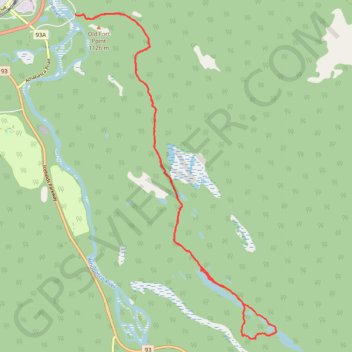
Interactive trail map

Trail profile

  • Distance: 12.0 mi
  • Elevation gain: 471 m
  • Maximum elevation: 1,167 m
  • Elevation loss: 476 m
  • Minimum elevation: 1,034 m

About this trail

Name: Valley of the 5 Lakes trail, distance, elevation, map, profile, GPS track

Start: Valley of the 5 Lakes Trail, Municipality of Jasper, Alberta, T0E 1E0, Canada (52.87111 -118.06098)

End: Valley of the 5 Lakes Trail, Municipality of Jasper, Alberta, T0E 1E0, Canada (52.87134 -118.06226)

Coordinates: 52.81370 -118.06226 52.87158 -118.00303

Other hiking, mountain biking, running and outdoor activity trails

Click on a trail to view its statistics, map and profile.

Jasper - Jasper National Park

Canada > Alberta > Municipality of Jasper

#Bike #Jasper

Distance: 51.3 mi • Elevation gain: 942 m • Maximum elevation: 1,602 m

Gear up for your next adventure:

🗺️Topographic Maps - Detailed maps showing elevation and terrain features
🔦Waterproof LED Headlamps - Hands-free lighting for evening treks and emergency navigation
🛰️Handheld GPS Devices - Reliable GPS units for hiking and outdoor navigation
🧺Microfibre Travel Towels - Fast-drying and compact towels for wild swimming and camping
🛌Sleeping Mats - Insulated mats for comfortable outdoor sleeping

As an Amazon Associate, this site earns from qualifying purchases at no extra cost to you.