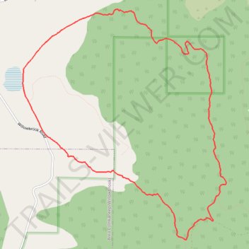
White Lake Loop Trail
- Distance: 6.9 mi
- Elevation gain: 345 m
- Maximum elevation: 650 m
- Elevation loss: 345 m
- Minimum elevation: 466 m
- Moving time: 1 h 30 m
- Moving speed: 4.6 mph
- Maximum speed: 7.5 mph
- Total time: 1 h 30 m
- Global speed: 4.5 mph
Interactive trail map
Trail profile
- Distance: 6.9 mi
- Elevation gain: 345 m
- Maximum elevation: 650 m
- Elevation loss: 345 m
- Minimum elevation: 466 m
- Moving time: 1 h 30 m
- Moving speed: 4.6 mph
- Maximum speed: 7.5 mph
- Total time: 1 h 30 m
- Global speed: 4.5 mph
About this trail
Name: White Lake Loop Trail trail, distance, elevation, map, profile, GPS track
Coordinates: 49.28739 -119.63197 49.31743 -119.59126
Other hiking, mountain biking, running and outdoor activity trails
Click on a trail to view its statistics, map and profile.
White Lake Grasslands Protected Area
Canada > British Columbia > Regional District of Okanagan-Similkameen > Area I (Skaha West/Kaleden/Apex)
Morning Trail Run ⛅
Distance: 7.1 mi • Elevation gain: 356 m • Maximum elevation: 650 m