Lake Minnewashta Vista Trail and Woodlands Loop
- Distance: 2.1 mi
- Elevation gain: 34 m
- Maximum elevation: 310 m
- Elevation loss: 34 m
- Minimum elevation: 290 m
Interactive trail map
Trail profile
- Distance: 2.1 mi
- Elevation gain: 34 m
- Maximum elevation: 310 m
- Elevation loss: 34 m
- Minimum elevation: 290 m
About this trail
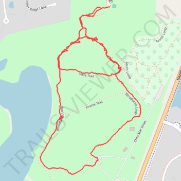
Name: Lake Minnewashta Vista Trail and Woodlands Loop trail, distance, elevation, map, profile, GPS track
Coordinates: 44.88087 -93.59108 44.88775 -93.58526
Other hiking, mountain biking, running and outdoor activity trails
Click on a trail to view its statistics, map and profile.
Woodlands Loop in Lake Minnewashta Regional Park
United States > Minnesota > Carver County > Chanhassen
Distance: 1.5 mi • Elevation gain: 27 m • Maximum elevation: 310 m