Thank you for supporting this site ❤️
Make a donation
Make a donation
Gear up for your next adventure:
As an Amazon Associate, this site earns from qualifying purchases at no extra cost to you.
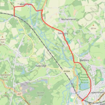
Romsey - Mottisfont & Dunbridge
- Distance: 5.5 mi
- Elevation gain: 52 m
- Maximum elevation: 47 m
- Elevation loss: 47 m
- Minimum elevation: 16 m
- Moving time: 44 m 16 s
- Moving speed: 7.4 mph
- Maximum speed: 10.0 mph
- Total time: 44 m 16 s
- Global speed: 7.4 mph
Interactive trail map
Thank you for supporting this site ❤️
Make a donation
Make a donation
Gear up for your next adventure:
As an Amazon Associate, this site earns from qualifying purchases at no extra cost to you.
Trail profile
- Distance: 5.5 mi
- Elevation gain: 52 m
- Maximum elevation: 47 m
- Elevation loss: 47 m
- Minimum elevation: 16 m
- Moving time: 44 m 16 s
- Moving speed: 7.4 mph
- Maximum speed: 10.0 mph
- Total time: 44 m 16 s
- Global speed: 7.4 mph
Thank you for supporting this site ❤️
Make a donation
Make a donation
Gear up for your next adventure:
As an Amazon Associate, this site earns from qualifying purchases at no extra cost to you.
About this trail
Name: Romsey - Mottisfont & Dunbridge trail, distance, elevation, map, profile, GPS track
Coordinates: 50.99209 -1.54726 51.03975 -1.48747
Topography: Test Valley topographic map, elevation, terrain
Thank you for supporting this site ❤️
Make a donation
Make a donation
Gear up for your next adventure:
As an Amazon Associate, this site earns from qualifying purchases at no extra cost to you.
Other hiking, mountain biking, running and outdoor activity trails
Click on a trail to view its statistics, map and profile.
Squabb Wook
United Kingdom > England > Hampshire > Test Valley > Romsey > Shootash
Distance: 4.9 mi • Elevation gain: 110 m • Maximum elevation: 73 m